Tom’s Thumb Trail Hike | McDowell Sonoran Preserve, Scottsdale AZ
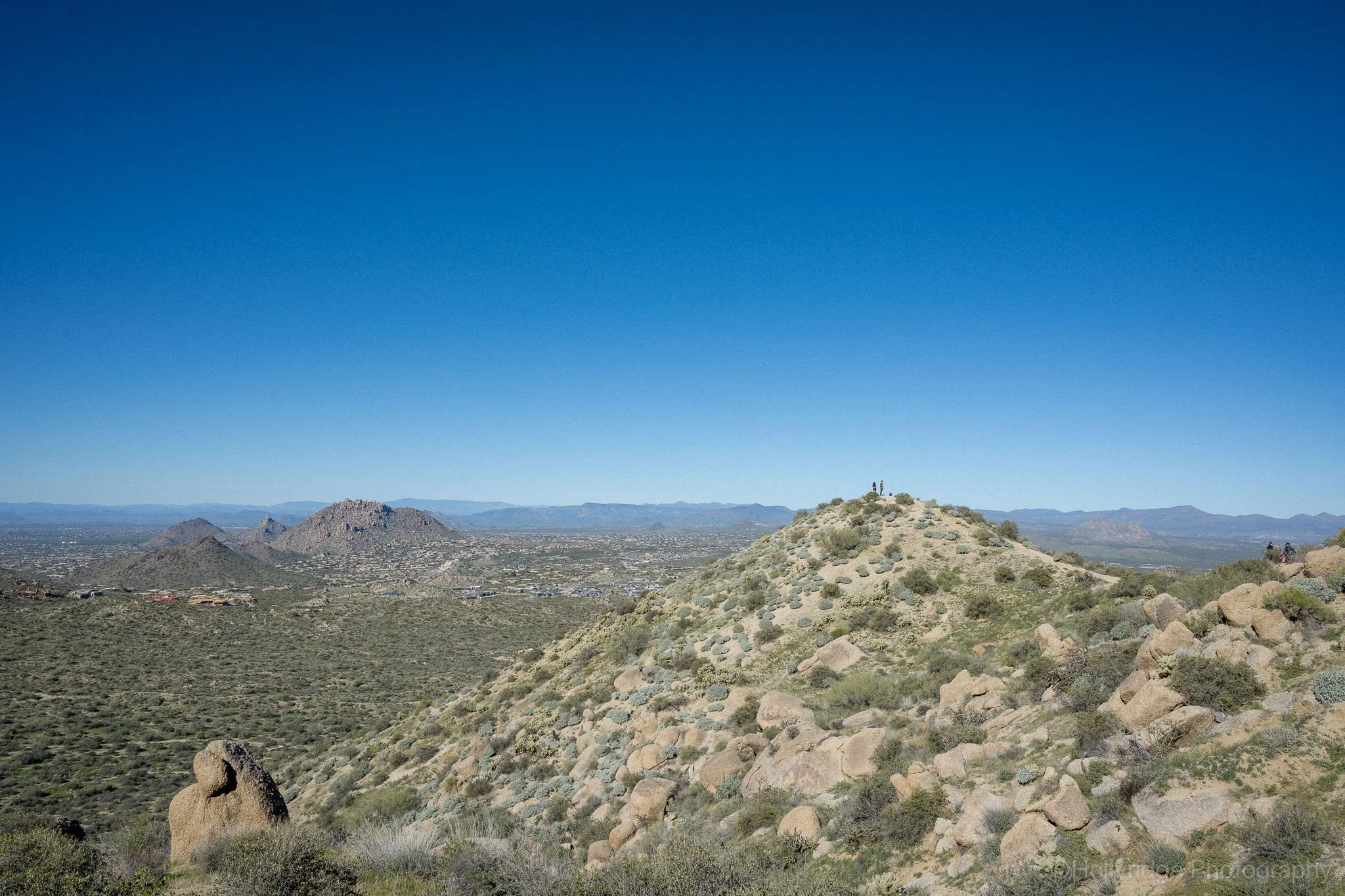
Hikers stopping to enjoy the vast views of Scottsdale.
Hiking Tom’s Thumb Trail in the McDowell Mountains
I had heard about the Tom’s Thumb Trail hike for years before finally doing it. Photos make it look dramatic yet clean, as if the trail gently leads you to the landmark. What they do not show is how steady the climb is or how exposed you feel once you are fully committed.
The trail sits inside the McDowell Sonoran Preserve, and from the first stretch, it felt honest. There’s a brief warmup section after leaving the entry, but it quickly ramps into the main rhythm of the hike.
I was joined by my usual hiking buddies: Nick and Bear.
Location and Trailhead Access
The start of the Tom’s Thumb Trailhead.
We started from the Tom’s Thumb Trailhead on the far northeastern edge of Scottsdale. It was easy to find, well-marked, and already busy even early in the morning. We arrived early enough to get parking, but it will fill up quickly.
Address (approximate):
23015 N 128th St, Scottsdale, AZ 85255
Parking: Free, but fills quickly during peak season (check the website for the seasonal hours)
Facilities: Restrooms, maps, water fountains (seasonal)
Trail Facts: Tom’s Thumb Trail Hike
Location: Scottsdale, Arizona
Trailhead: Tom’s Thumb Trailhead
Distance: ~4 miles round trip
Elevation Gain: ~1,200 feet
Difficulty: Moderate
Trail Type: Out-and-back
Estimated Time: 2–3 hours
Best Season: November–March
Dogs Allowed: Yes, on leash
Shade: Minimal
Facilities: Restrooms at the trailhead
📍 One of the most popular and scenic hikes in the McDowell Mountains, known for its granite formations and panoramic desert views.
The First Stretch
The trail started out manageable. It was not steep at first, just a constant series of rolling hills. The kind of rolling hills that slowly force you into a slower pace than expected.
Cholla and creosote lined the trail, and granite boulders were scattered across the hillsides. After about ten minutes, my breathing changed. Not struggling yet, but definitely working.
Nick seemed to handle the early climb better than I did. That might have had something to do with Bear pulling him uphill like a desert-based sled dog for the first part of the hike.
Feeling the Climb
As we gained elevation, the uphill grade was more than I expected. My lungs were burning, and I found myself stopping more often. Every pause came with a reward, though. Each time I turned around, the view opened up a little more.
As I rounded one switchback, the hillside fell away and the valley opened up in front of me. The parking lot disappeared. The desert below looked flatter and quieter. That moment alone made the effort feel worthwhile.
The switchbacks kept coming, and my pace slowed again. Hikers passed us on the way down, some breathing hard, others already relaxed. Everyone looked satisfied in the way people do when they know the climb paid off.
Seeing Tom’s Thumb
Tom’s Thumb from about mid-way of the trail.
I didn’t immediately recognize Tom’s Thumb when it first came into view. It blended in with the surrounding rock formations, and for a moment, I was not sure which formation we were heading toward.
A few more steps made it obvious.
From there, the trail became steeper and rockier. I paid closer attention to where I was stepping, especially as the path narrowed and the exposure increased. The sun felt stronger, and the lack of shade became impossible to ignore.
This is also where we learned a practical lesson about hiking with a dog in the desert. Watch out for chollas if you bring a dog. We had to stop and pull a cholla spike out of Bear’s paw, which took patience, but he really is the best boy.
Why We Took the Main Trail
Go in Spring or after a rain fall to experience the bright green hills.
I have heard people talk about reaching Tom’s Thumb from longer routes like Windgate Pass or Bell Pass. Those options add distance and solitude, but on this hike, the main trail felt right.
It was direct without being rushed and challenging without being overwhelming. We never had to think about navigation, which let us focus on the climb, the views, and keeping Bear moving safely through rocky sections.
Timing and Conditions
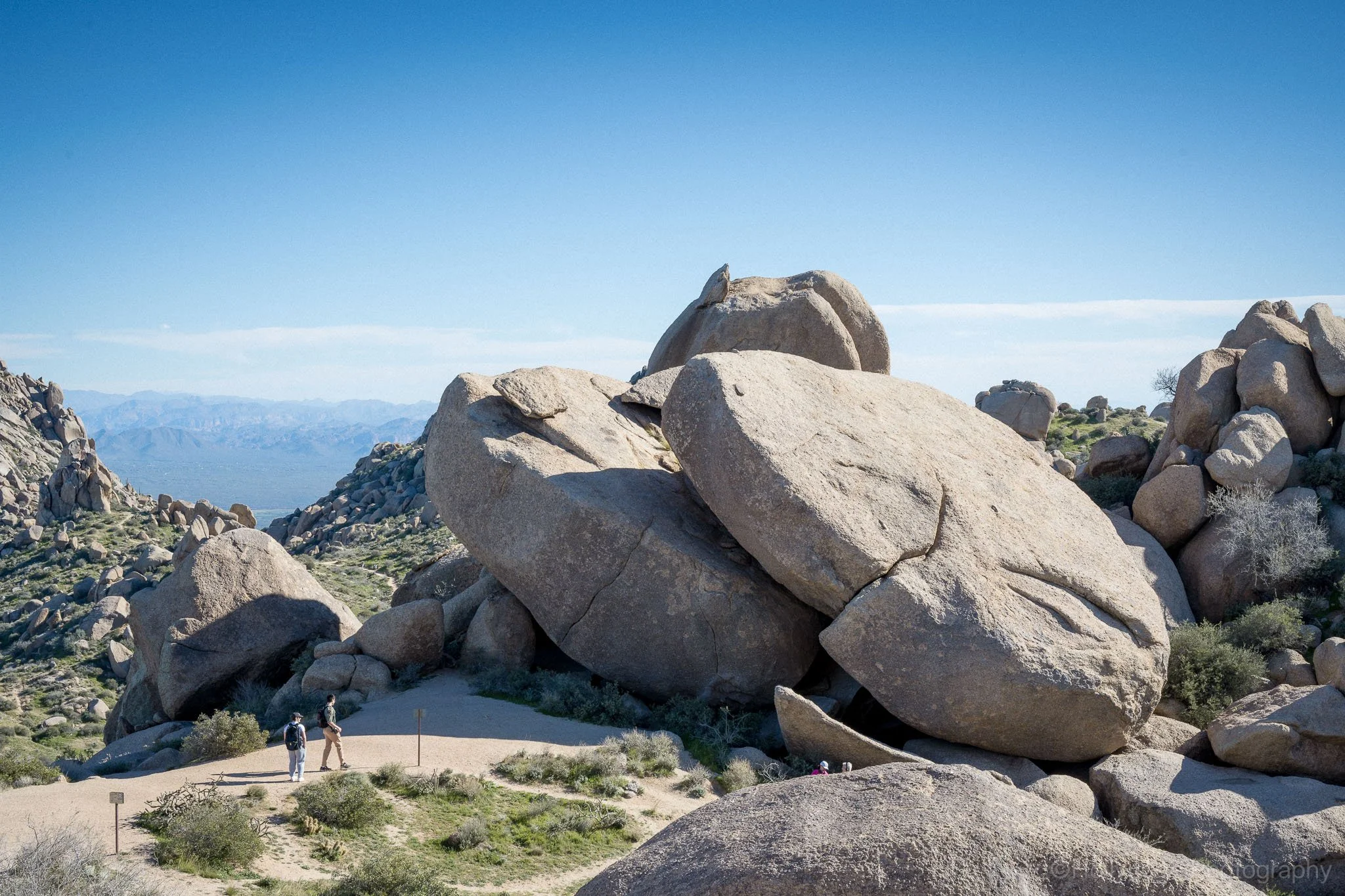
It’s hard to really get a scale for the boulders in this area!
We hiked in cooler weather, and I would not want to do this trail any other way. Even then, the exposure was noticeable, and I was glad we started early.
In summer, this hike would be unforgiving. There is very little shade, and once you are climbing, there is no quick exit. Good shoes, plenty of water, and realistic expectations matter here.
Hiking Tom’s Thumb with a Dog
Tom’s Thumb is dog-friendly, and we saw several dogs on the trail, all leashed. The rocky sections and cholla are real considerations, especially for paws.
If I hike this trail with Bear again, it will be in winter, early in the day, and with extra water. The terrain is manageable, but it requires attention.
Reaching the Top
Standing near the base of Tom’s Thumb, the scale finally registered. The formation was much larger up close, rough and worn in a way that only time creates.
We dropped our packs, drank more water than planned, and sat longer than expected. From that spot, Scottsdale spread out below us. Beyond it, the desert softened into layers and haze.
I took a few photos, then put the camera away. It felt like a place where staying present mattered more than documenting it.
What Stayed With Me
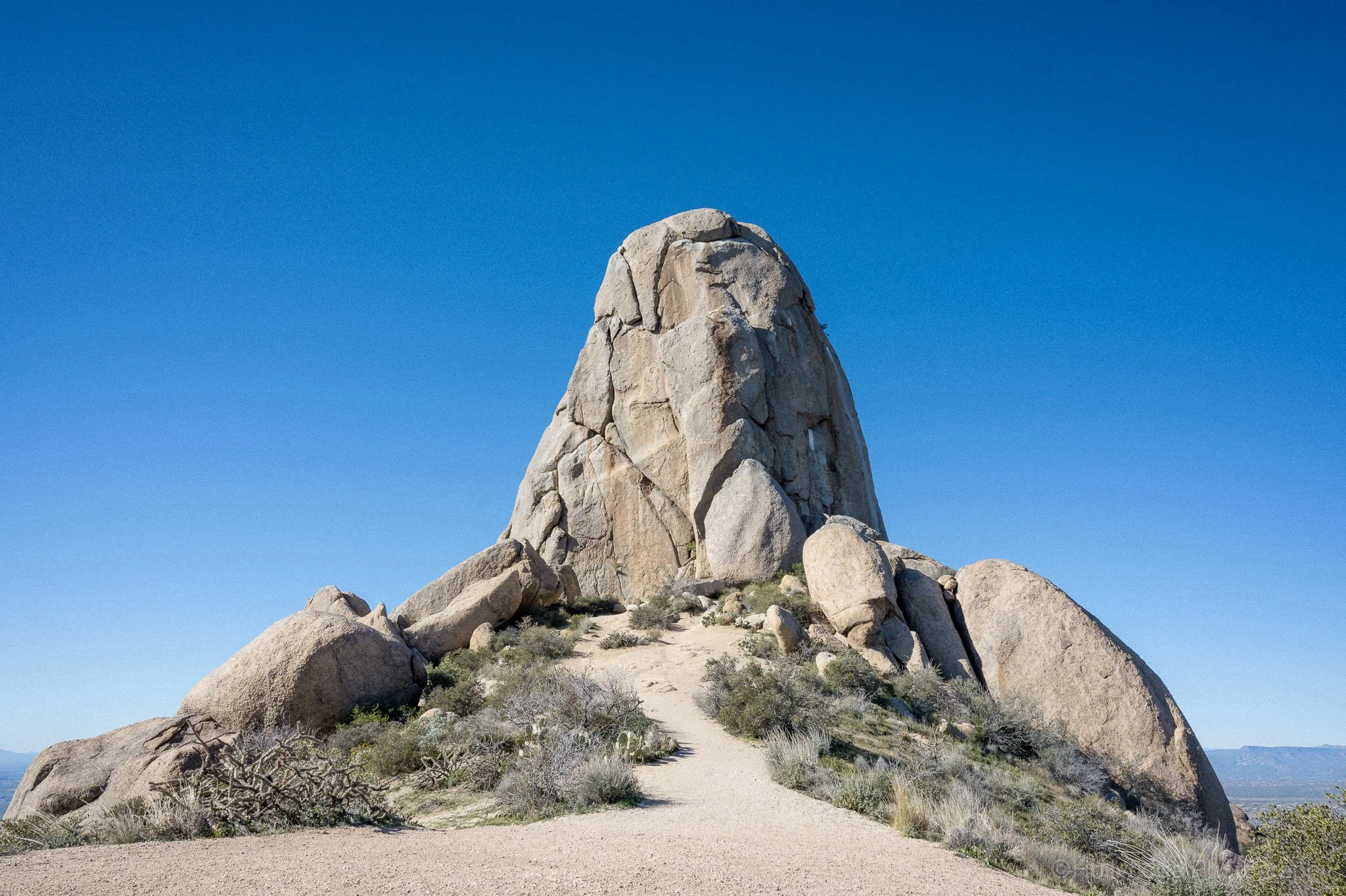
The unexpected size of Tom’s Thumb really takes your breath away. If you’re lucky, you’ll see climbers ascending to the top!
Some hikes stand out because they are long. Others because they are difficult. Tom’s Thumb stayed with me because of how aware it made me feel of my breathing, my pace, and the steady effort it demanded.
It was not a hike I rushed through. It was one I felt the entire way up.
That is why I would go back.
Check our other hiking guides for more hiking inspiration.
If you’re more interested in the images than the mileage, you can explore my Arizona landscape photography portfolio for more desert light and mountain textures.